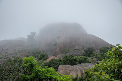
Nijagal Betta (Hale Nijagal / ಹಲೆ ನಿಜಾಗಲ್)
Nijagal Betta has got to be the closest, simplest, and fastest getaway from Bangalore. It is located after Dobbespet on the Bangalore-Tumkur highway (aka Tumkur Road). It is fairly isolated and yet safe.
Parking your vehicle on the highway is not an issue and you can always have a steaming cappuccino at the CCD at the foothill to pump up your energy.
Coming to the fort, the place is also known as 'Hale Nijagal' which translates to 'Old Nijagal'. Although it may not inspire awe compared to its neighbors such as Channarayana Durga, Devarayanadurga, and Madhugiri, it does have its own aura when viewed from the highway as it stands tall upon the hill
I first explored this hill fort in 1992. At that time, it had an upcoming dargah as well as some old temples in ruins. Now, after 30 years, some more pucca mosques have come up and there seems to be electrical connectivity. Having said that, the place still retains its isolated charm.
PS: You will get mobile signals here
I normally recommend going there very early (say by 7:00 am). I dare say that you will finish your trek in less than two hours even if you explore every nook and corner.
If you are lucky, you will also experience a walk in the clouds as they envelop you.
The place does attract visitors and I cannot comment on the type of crowd that comes on weekends and during peak hours.
I could not glean much information about its history except that it dates back to Hyder Ali's time and was a fighting point between the Marathas and Hyder Ali. Once I get some more authentic information, I will update the blog accordingly.
Police station: Dobbspet
Petrol Bunk/Puncture Shops/Cafe/Restaurants/Dhabas: All within 2 kilometers from the foot of the hill
Nearest Railway Station: Dobbspet
Nearest Airport: Really now?
Location: https://goo.gl/maps/ScVri74zp6K8a8PJ9


Comments
Post a Comment